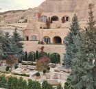
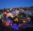
Museum Hotel / Uçhisar, Cappadocia
Cappadocia
Buy or gift a digital subscription and get access to the complete digital archive of every issue for just £18.99 / $23.99 / €21.99 a year.
Buy/gift a digital subscription Login to the Digital Edition
John Henry Haynes' 1884 photograph of a Roman tomb in Avılar. The tomb is now eroded and eveloped by the town of Goréme. Below: Bird's eye view of Cappadocia, by Jürgen Frank, from By Horseback Through the Volcanic Valleys, Cornucopia 35
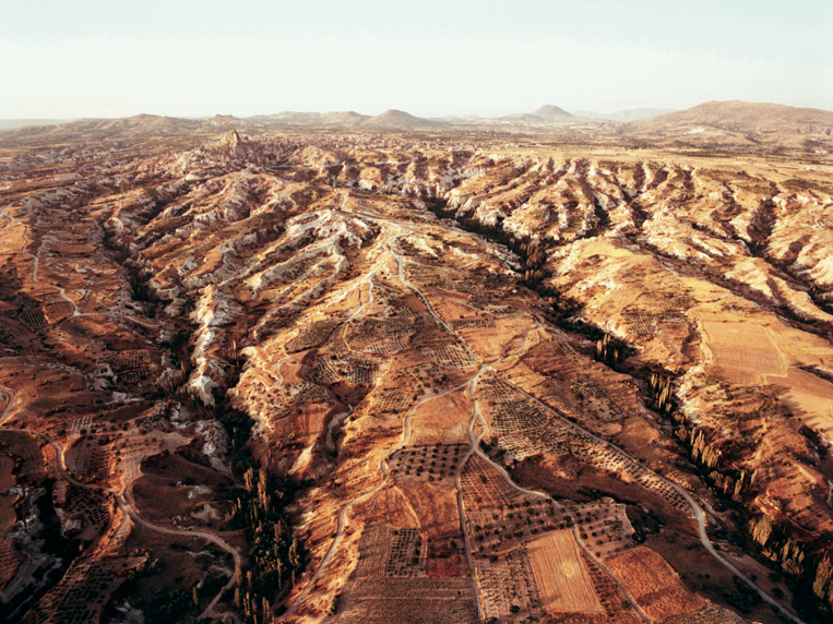
“Altogether these rock formations and the multitude of excavated dwellings… appear to me now the most wonderful thing I have ever been permitted to rest my eyes upon in all my travels and among all the wonderfully interesting things it has been my good fortune to see in the land of wonders.” So wrote John Henry Haynes, the father of American archaeological photography, in 1884, and some of his pictures were reproduced in Cornucopia 44. The can now also be seen in John Henry Haynes: A Photographer and Archaeologist in the Ottoman Empire 1881–1900. A visitor today will be similarly awed at the famous fairy chimneys, rock-cut Byzantine churches and lunar landscapes. The volcanic lands of Cappadocia stretch across 400km of the high plateau of central Anatolia. Once the Hittites' domain, its later warlords were famous for their horsemanship, and from their number came the powerful Comnenus dynasty of Byzantium. Cappadocia's ancient name was Katpatuka, meaning Land of the Beautiful Horse, and for a remarkable 30-page feature in Cornucopia 35, photographer Jürgen Frank saddled up to capture the beauty of the landscape while Susan Wirth described a five-day ride from Avanos to Mustafasa. The miles of underground caves have a constant temperature of 13 deg C, and are ideal for bulk storage of fruit and vegetables.
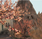
Fruits are preserved in wonderful jams, and preserves. In Cornucopia 56, Beren Torolsen visits the area, and gives delicious traditional recipes for preserves, stews and desserts using apricots, and Robert G Ousterhout's book Visualising Community: Art, Material Culture,and Settlement in Byzantine Cappadocia is reviewed. Ousterhout also writes on Cappadocia through the eyes of early Western travellers in Cornucopia 59.
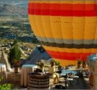
One of the best ways to view the extraordinary rock formations is by hot-air balloon. On land there is a panoramic view from the citadel at Üçhisar with the the snow-capped capped Erciyes Dağı to the east, a reminder of the volcanic eruption that created this unique landscape. Cappadocia’s man-made achievements lie underground, in communities carved out of the soft volcanic tuff in what the Byzantines called the Land of the Troglodytes. Hermits and monks came here from the 4th century, and the 3,000 churches and chambers around the provincial capital of Nevşehir, ancient Nyssa, date largely from the 9th century. The concentration of painted churches and monasteries at Göreme has become an open air museum, and further discoveries are being made. In 2013 an urban development around the castle at Nevşehir unearthed an enornous underground city, and when excavations began in 2015 it was estimated that as many may have lived here as in Derinkuyu, which provided homes for 20,000 people.
Derinkuyu can be visited, as can Ürgüp and Kaymaklı, all of which are within easy striking distance of Nevşehir, and at Ozkonak near the ceramic town of Avanos. Ürgüp is a good base for visiting the area.
The ash and lava fields created fertile valleys of fruit and sunflowers and its winelands are described in Cornucopia 31. The 15km Ilhara Canyon, known as Anatolia's Garden of Eden, is the most spectacular gorge in the region.
One of the best ways to view the extraordinary rock formations is by hot-air balloon. On land there is a panoramic view from the citadel at Üçhisar with the the snow-capped capped Erciyes Dağı to the east, a reminder of the volcanic eruption that created this unique landscape. Cappadocia’s man-made achievements lie underground, in communities carved out of the soft volcanic tuff in what the Byzantines called the Land of the Troglodytes. Hermits and monks came here from the 4th century, and the 3,000 churches and chambers around the provincial capital of Nevşehir, ancient Nyssa, date largely from the 9th century. The concentration of painted churches and monasteries at Göreme has become an open air museum.
Underground cities can be visited at Derinkuyu, Ürgüp and Kaymaklı, all within easy striking distance of Nevşehir, and at Ozkonak near the ceramic town of Avanos. Ürgüp is a good base for visiting the area.
The ash and lava fields created fertile valleys of fruit and sunflowers and its winelands are described in Cornucopia 31. The 15km Ilhara canyon, known as Anatolia’s Garden of Eden, is the most spectacular gorge in the region.
The transport hub is the provincial capital of Nevşehir, where there is an airport, though the airport at Kayseri has more flights and rail connections. Göreme is 290 miles southeast of Ankara, 70km from Kayseri and 18km from Nevşehir.
Read the Overland Site road adventure to Cappadocia here.

Cornucopia works in partnership with the digital publishing platform Exact Editions to offer individual and institutional subscribers unlimited access to a searchable archive of fascinating back issues and every newly published issue. The digital edition of Cornucopia is available cross-platform on web, iOS and Android and offers a comprehensive search function, allowing the title’s cultural content to be delved into at the touch of a button.
Digital Subscription: £18.99 / $23.99 (1 year)
Subscribe now