Buy or gift a digital subscription and get access to the complete digital archive of every issue for just £18.99 / $23.99 / €21.99 a year.
Buy/gift a digital subscription Login to the Digital EditionRobert Ousterhout spies the wonders of Anatolia through the eyes of early Western travellers
For European travellers of the 18th and 19th centuries, Anatolia was a place full of adventure and discovery, replete with eccentric mythologies and historical mysteries – a heady mixture
of the exotic Orient and the ruins of classical antiquity.
And so much more: strange
and majestic landscapes, evocative remains of unknown civilisations, and a quaint and curious peasantry. Much may have been exaggerated in the early written accounts,
perhaps the fault of unreliable or gullible narrators, and the European public often
remained suspicious – and curious. Nevertheless, the
early explorers provide a first glimpse of the thriving Byzantine centres of central Anatolia, away from the more familiar and more easily accessible classical sites along the coast.
The account left by the British archaeologist and explorer Gertrude Bell (1868–1926) recounting her explorations on the high plateau in 1905–09 captures something of the romance that had lured earlier travellers to the region: “It is Asia, with all its vastness, with all its brutal disregard for life and comfort and the amenities of existence; it is the ancient East, returned, after so many millenniums of human endeavor, to its natural desolation. If this is the first it is also the final impression. The further the traveller goes, the more thoroughly he studies the vestiges of many civilisations, old and new and all alike decayed, the more deeply will he be convinced of the Asiatic character of the land… The West may have conquered here, organised governments and built towns, … [but] it was the East that conquered the conqueror… The East pursued its deep and silent way, assimilating what was brought to it and passed it out again marked with its own stamp.”
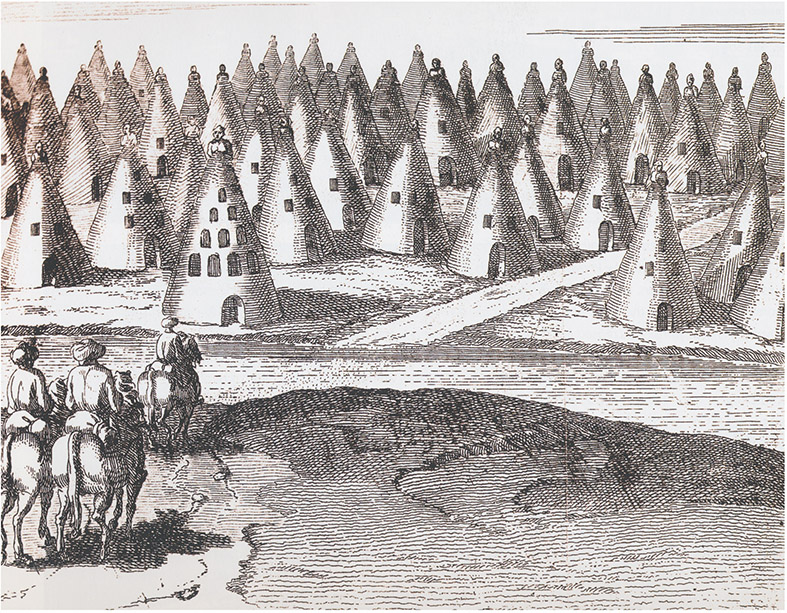
Probably the earliest of the European adventurers to travel to inland Anatolia was the Frenchman Paul Lucas (1664–1737), who had been sent by the French government to survey the lands around the Mediterranean in the early years of the 18th century. He came away from his venture through Cappadocia with bizarre tales: bodies cast out of their tombs but mysteriously finding their way back; unexplained fires amid the landscape; and a monstrous beast whose laugh compelled those who heard it to follow, never to be seen again. If that was not enough to strain the credulity of his readers, Lucas’s description of the landscape seems equally improbable. Near the Kızılırmak River, he reported seeing strange “pyramidical houses” carved with windows and doors, decorated with paintings on the inside. On the tops of these pinnacles he thought he saw sculpted busts of hooded monks or of the Virgin and Child, and on this basis he suggested these might have been the dwellings of early Christian hermits. On closer examination, however, he noted that some had pagan subjects, and some were indecent.
Lucas’s narrative integrity was not aided by the one illustration he provided for this remarkable landscape – no doubt drawn for publication by an innocent illustrator, based on Lucas’s descriptions. For those who have travelled in Cappadocia, the image might call to mind the fairy chimneys around Zelve or the Devrent Valley, with their evocative pinnacles and caps. But for a European audience of the 18th century, Lucas’s pyramidical houses must have seemed utterly fabulous and easily dismissed as the product of an overactive imagination.
By the mid-19th century, more reliable accounts began to appear. One of the earliest 19th-century travellers was also one of the most prolific. Léon de Laborde (1807–69), who ventured into central Anatolia in 1826 at the tender age of 18, travelling with his aged father, Alexandre, who was carried, reclining in a tahtaravan, or litter, and was thus often mistaken for an Oriental potentate – an impression enhanced by the entire party dressing in Ottoman costumes. The account of their journey, published in 1837, was profusely illustrated with romanticised, if reasonably accurate, lithographs. These
are particularly valuable
records of lost monuments, such as the gates of Konya and the site of the early Byzantine settlement at Binbirkilise,
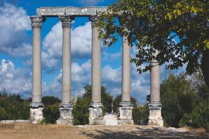
and their accuracy can be measured against Laborde’s images of surviving monuments, as at Iznik, Aphrodisias or Alahan.
Laborde’s contemporary Charles Texier (1802–71) ventured into inland Anatolia during his travels of 1833–37. After excavating in France and Italy, he was sent by the French ministry of culture on an exploratory mission to the Ottoman Empire in 1833, and subsequently published several illustrated accounts of his travels to the East, the first in 1839. In addition to detailed architectural drawings, he published a number of evocative landscape views. With Richard Popplewell Pullan he subsequently published Byzantine Architecture (London, 1864), the first book dedicated to the subject. Unfortunately, the two tended to idealise and visually restore what they recorded. For example, their view of a rock-carved façade at Ürgüp cannot be matched with any of the surviving façades in the region. By contrast, Texier’s unpublished drawings, preserved at the Royal Institute of British Architects, are much more accurate than his published images.
The 19th century saw numerous British adventure-scholars who, like Texier and Laborde, were more attracted to the challenges and potential for discovery in Anatolia than to Constantinople. William F Ainsworth (1807–96) and William J Hamilton (1805–67) led the way, writing learned, illustrated books based on their travels. Both were well read and interested in the historical geography of the places they visited, and they left important early accounts of the rock-cut settlements of Cappadocia. Ainsworth illustrated his text with vignettes, such as a curious balancing rock from Cappadocia, while Hamilton’s views are similar to those of Texier – accurate but slightly romanticised.
The wilds of Anatolia were eventually tamed by European cartographers, augmented with the advent of photography, which allowed more scientific methods of documentation. The German cartographer Heinrich Kiepert (1818–99) travelled to Anatolia in the 1840s as a part of a large, systematic project to map the geography of the classical world, and his project was continued through the century. Notable among his successors was the Scot Sir William Mitchell Ramsay (1851–1939), who travelled extensively in Anatolia, beginning in 1880 and continuing until the outbreak of war made it impossible.
When he began his investigations in Anatolia, very few historical places could be fixed with certainty. For geographical identification, he formulated a broad approach, taking into consideration sites from all periods, including the Byzantine, and he employed evidence that had been previously neglected or underutilised, such as local coin types, the writings of Christian authors, and legends. His study of historical geography, published in 1890, remains fundamental. Most of the earlier scholars had limited
their explorations to the library, but as Ramsay realised, this
sort of study only made sense with a profound knowledge of the land itself. In 1907–09,
Ramsay collaborated with Gertrude Bell on the excavations at Binbirkilise, the early Byzantine settlement visited by Laborde. For the publication, Bell travelled separately across Anatolia on horseback, recording Byzantine churches with measured drawings and photographs.
The resulting study, published in 1909 and richly illustrated,
is invaluable, as many of the sites she records have subsequently disappeared. Bell left behind more than 6,000 photographs from her travels.
Travel with photographic equipment was not easy in the 19th century and was often limited to the easily accessible coastal regions. As early as 1842–46, Joseph-Philibert Girault de Prangey (1804–92) took daguerrotypes of classical sites along the west coast of Anatolia (as well as in Greece, Syria, Palestine and Egypt), but the technique did not lend itself to replication or publication.
The invention of the photographic negative allowed for the reproduction of
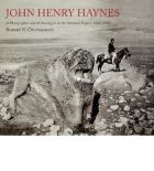
images, and by the end of the century, photographs became standard elements in archaeological publications, although not without some resistance. John Henry Haynes (1849–1910) made two photographic expeditions across Anatolia in 1884 and 1887, but his photographs never found a wide audience. For the initial reports on the excavations at Assos, for which Haynes served as photographer, his images were redrawn for publication, and his contribution went uncredited. When Sir William Ramsay and Gertrude Bell published The Thousand and One Churches in 1909, illustrated with hundreds of Bell’s photographs, one reviewer dismissed it as a “picture book”. Nevertheless, photography provided a degree of authenticity unimagined by earlier travellers.
Gertrude Bell’s enthusiasm for “Oriental” architecture, as well as her method of analysis, owes much to the work of the Austrian scholar Josef Strzygowski (1862–1941), to whom Ramsay and Bell dedicated their publication. Although remembered today for his racist, proto-Nazi ideology, Strzygowski energised a generation of scholars, championing the Oriental origins of medieval art and architecture. His 1903 publication, Kleinasien ein Neuland der Kunstgeschichte, proclaimed Anatolia “a
new land of art history” and encouraged further exploration of the region.
In fact, the first decade of the 20th century was the golden age for Anatolian exploration, with German, Austrian, French, British, Turkish and American adventurer-scholars traversing the landscape. The German scholar Hans Rott (1876–1942) made a documentary sojourn across Anatolia in 1906, similar to that of Bell. He added many new Byzantine monuments to the repertory, as he travelled along the southern coastlands. Ernst Emil Herzfeld and Samuel Guyer surveyed and excavated in Cilicia in 1907, although their results were published much later. Perhaps most important and influential was the French Jesuit missionary Guillaume de Jerphanion (1877–1948), who was stationed in Tokat in the early years of the 20th century. From there he began to explore and systematically document the rock-cut churches of Cappadocia, making his first of many expeditions into the region in 1907. His fundamental corpus of the painted churches was published only after World War I, but it established a methodology for examination and documentation still followed today. Like Strzygowski, Jerphanion realised there was much yet to be discovered in Anatolia, proclaiming Cappadocia Une nouvelle province de l’art byzantin, as he titled his multi-volume study.
Unfortunately, the period of intensive exploration came to an end with the turmoil of the the Balkan Wars, the First World War, the breakup of the Ottoman Empire, and the Turkish War of Independence; many of the monuments documented by early explorers have vanished without a trace. For those that survive, textual sources are almost completely absent, and their histories must be reconstructed from the archaeological evidence and historical context. Many are today isolated ruins, with no trace of settlement nearby and nothing to indicate why they were built; others have been converted into mosques.
Is Anatolia still ein Neuland der Kunstgeschichte, une nouvelle province de l’art byzantin? Following Jerphanion’s lead, French scholars such as Nicole Thierry and Catherine Jolivet-Lévy have for decades made new and astounding discoveries of the Byzantine monuments of Cappadocia, and their discoveries have encouraged Turkish, American and Italian scholars to pursue further documentation of the region, which is now emerging as the best-preserved area of Byzantine civilisation, providing a mirror onto daily life in the Byzantine Empire. Investigations in Phrygia and along the south coast are yielding similarly rich results, and even Iznik and Izmit continue to provide surprises. Pollen data, climate analysis and other scientific techniques are adding useful nuances to the complex political history of the region. In short, Anatolia may no longer be the wild, wild East, but it still holds great potential for Byzantine scholarship.
Robert Ousterhout is the author of ‘Visualizing Community: Art, Material Culture, and Settlement in Byzantine Cappadocia’ (Dumbarton Oaks, 2017) ‘John Henry Haynes’ (Cornucopia, 2nd ed, 2016) and ‘Eastern Medieval Architecture: The Building Traditions of Byzantium and Neighboring Lands’, due from Oxford University Press, September 2019
Francis Russell drives the highways and byways of Rough Cilicia

Berrin Torolsan on the wonders of white cheese
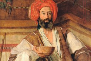
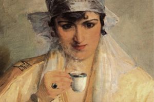
Described by his friend the novelist William Makepeace Thackeray as ‘a languid Lotus-eater’, the Victorian Orientalist JF Lewis travelled to Turkey and Egypt and recreated what he saw of Ottoman life in loving, exotic detail – often painting himself and his wife into his pictures clad in elaborate local dress. Briony Llewellyn looks back over a life of many colours
Fascinated by the many faces of Mihri Rasim, Jamie Leptien asks how and why this unique artist has been ignored for so long
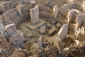
Six millennia before Stonehenge, the dawn of the agrarian revolution came to the now arid Anatolian steppe – and with it came Göbekli Tepe, perhaps the first place of worship built by man. With its T-shaped columns and menacing animal carvings, it is an unacknowledged wonder of the ancient world. But who built it? And what went on here? By Barnaby Rogerson
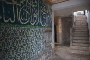
As the Topkapi prepares to open up parts of the palace long kept hidden, we recall the time Cornucopia was granted rare access to what remains the most secret section of all – the quarters of the Black Agas. These powerful African eunuchs guarded the Harem and controlled the finances of the hugely wealthy Queen Mother. Text by Berrin Torolsan. Photographs by Fritz von der Schulenburg
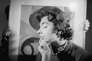
Yildiz Moran abandoned photography for lexicography at the age of 30. But her decade behind the lens left an astonishing body of work, celebrated this year at Istanbul Modern. By Jamie Leptien

‘How my grandfather took Iznik to Yorkshire’ by Christopher Simon Sykes


Cornucopia works in partnership with the digital publishing platform Exact Editions to offer individual and institutional subscribers unlimited access to a searchable archive of fascinating back issues and every newly published issue. The digital edition of Cornucopia is available cross-platform on web, iOS and Android and offers a comprehensive search function, allowing the title’s cultural content to be delved into at the touch of a button.
Digital Subscription: £18.99 / $23.99 (1 year)
Subscribe now